 |
| We love every minute of Niagara Falls! The falls are so beautiful. |

 |
| Famous, towering waterfalls at the boundary of Canada & the United States |
 | |
| behind us, Niagara SkyWheel is a 175-foot tall Ferris wheel, Dinosaur Adventure and the Casino. |

Niagara on Falls was a beautiful little town. Meal in Sheraton was excellent. Boat trip along the falls superb. Lot's opportunity for pictures. walk along the side of horshoe to see the drop was stunning. Love the whole day out. It has everything you want, the magnificent falls, the cruise, the lunch from the 12th floor of a nice hotel with an astonishing view was absolutely amazing.
HONEYMOON CAPITAL OF THE WORLD"NIAGARA FALLS"!
Engage couples choose Niagara Falls as their romantic getaways, secluded picnic areas, dense trees, fragrant flowers and the sound of broods and water falls set the scene by day,intimate little restaurants, candlelight and wine by night. Awesome!
If you are looking for a learning vacation, get it here! there are plenty of places to explore discover and experience go through all the attractions available, you will understand why families and young returns to Niagara Falls year after year. It was a great and amazing experience..
If
you are one looking for a learning vacation, get it here! - See more
at:
http://www.infoniagara.com/attractions/index.aspx#sthash.UQVyLm5E.dpuf
Niagara Falls has a mystique unequalled anywhere. One word can be used to describe why thousands of honeymooners and second-honeymooners come to our city each year - Romance. Romantic getaways,
secluded picnic areas, dense trees, fragrant flowers and the sound of
broods and waterfalls set the scene by day; intimate little
restaurants, candlelight and wine by night.
Today, engaged couples choose Niagara Falls as their honeymoon destination twelve months of the year, but especially May through October. Every type of special once-in-a-lifetime honeymoon suites in Niagara Falls can be found at the major hotels.
Since Niagara Falls loves "LOVERS", every honeymoon couple receives an official honeymoon certificate signed by our Mayor - a treasure for years to come. Along with the certificate the bride receives a free pass to many of the local attractions.
- See more at: http://www.infoniagara.com/history/honeymoon_city.aspx#sthash.eFpDHZ7d.dpuf
Also must see within the Niagara Parks Commission Region is the Floral Clock located at 14004 Niagara Parkway in Queenston.Today, engaged couples choose Niagara Falls as their honeymoon destination twelve months of the year, but especially May through October. Every type of special once-in-a-lifetime honeymoon suites in Niagara Falls can be found at the major hotels.
Since Niagara Falls loves "LOVERS", every honeymoon couple receives an official honeymoon certificate signed by our Mayor - a treasure for years to come. Along with the certificate the bride receives a free pass to many of the local attractions.
- See more at: http://www.infoniagara.com/history/honeymoon_city.aspx#sthash.eFpDHZ7d.dpuf

And the Excellent place to take your family to visit Niagara Parks Butterfly Conservatory.
This butterfly conservatory is tremendous and butterfly fans should really visit. It has an admission and parking fee, but it is worth it. There is an indoor biome with more butterflies than you can imagine, with 40 types of different species of butterflies. It is such a spectacular thing to see. Also, you will be up close to the butterflies and if you are lucky a butterfly will land on you. There are so many butterflies, you might step on one or run into one if you are not careful. It was so beautiful, Fun, and informative and nothing exciting or thrilling but a great family outing.


The Skylon Tower, in Niagara Falls, Ontario, is a revolving restaurant and an observation tower that overlooks both the American Falls, New York, and the larger Horseshoe Falls, Ontario, from the Canadian side of the Niagara River.


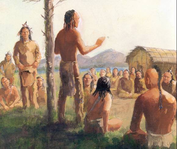
The first humans arrived in Niagara Region almost 12,000 years ago, just in time to witness the birth of the Falls. The land was different then, consisting of tundra and spruce forest. During this time (the Palaeo-Indian Period, which lasted until 9,000 years ago), Niagara was inhabited by the Clovis people. These nomadic hunters likely camped along the old Lake Erie shoreline,
living in simple, tiny dwellings. They left little to mark their tenure
except chipped stones. These large, fluted projectile points were
likely to fell the caribou, mastodons, moose and elk that roamed the
land.
 By 9,500 years ago a deciduous forest apparently covered southernmost Ontario. This forest supported the hunter-gatherers of the Archaic Period (9,000
to 3,000 years ago) with a diet of deer, moose, fish and plants. Small
groups hunted in the winter, feeding on nuts and animals attracted to
the forest. Larger groups came together during the summer, setting up
fishing camps at the mouths of rivers and along lakeshores.
By 9,500 years ago a deciduous forest apparently covered southernmost Ontario. This forest supported the hunter-gatherers of the Archaic Period (9,000
to 3,000 years ago) with a diet of deer, moose, fish and plants. Small
groups hunted in the winter, feeding on nuts and animals attracted to
the forest. Larger groups came together during the summer, setting up
fishing camps at the mouths of rivers and along lakeshores.
The Woodland Period lasted from 3,000 to 300 years ago, culminating in the peak of Iroquois culture in southern Ontario. Corn, bean and squash agriculture provided the main sources of food. With their bellies full, the Iroquois had time for other pursuits and the population boomed. Small palisaded villages were built, with nuclear or extended families occupying individual longhouses. During this period, burial rituals and ceramics were introduced to Ontario. Society became more complex with a political system based on extended kinship and inter-village alliances.
When the European explorers and missionaries arrived at the beginning of the 17th Century, the Iroquoian villages were under the direction of various chiefs elected from the major clans. In turn, these villages were allied within powerful tribal confederacies.
Unfortunately, inter-tribal warfare with the Five Nations Iroquois of New York State, made worse by the intrusion of the Europeans, dispersed the three Ontario confederacies, the Huron, the Petun and the Neutral. Niagara ceased to be the territory of those who lived in harmony with nature. Still, this fascinating period of native occupation cries out for interpretation and study. Since human settlement requires drinking water, sites within 150 metres of rivers and lakeshores have the greatest archaeological potential. Palaeo-Indian sites in Niagara would most likely be associated with the series of relic beach ridges that once formed the shore of early Lake Erie.
In May 1535, Jacques Cartier left France to explore the New World. Although he never saw Niagara Falls, the Indians he met along the St.Lawrence River told him about it. Samuel de Champlain visited Canada in 1608. He, too, heard stories of the mighty cataract, but never visited it. Etienne Brule, the first European to see Lakes Ontario, Erie Huron and Superior, may also have been the first to behold the Falls, in 1615.
That same year, the Recollet missionary explorers arrived in Ontario. They were followed a decade later by the Jesuits. It was a Jesuit father, Gabriel Lalemant, who first recorded the Iroquios name for the river- Onguiaahra, meaning "the Strait". "Niagara" is a simplification of the original.
In 1651, during the fur- trade rivalry between the Huron and Iroquois that was first precipitated by the French, the Iroquois wiped out the Neutrals. Until the American Revolution, they managed to keep white settlers out of Niagara almost completely.
In December 1678, Recollet priest Louis Hennepin visited Niagara Falls. Nineteen years later, he published the first engraving of the Falls in his book Nouvelle Decouverte. The Falls obviously made a great impression of Hennepin, for he estimated their height to be 183 metres, more than three times what it really is.
In 1812, by request of President James Madison, the United States congress declared war on Canada. Artifacts from that war dot the riverside, as do monuments erected later, such as the one to Sir Isaac Brock. Recently, the skeletons of members of the U.S. Army were found near Old Fort Erie.
Following the War of 1812, the region began the slow process of rebuilding itself. Queenston became a bustling community, but Chippawa was the big centre, with distilleries and factories.
In the 1820's, a stairway was built down the bank at Table Rock and the first ferry service across the lower River began. By 1827, a paved road had been built up from the ferry landing to the top of the bank on the Canadian side. This site became the prime location for hotel development and the Clifton was built there, after which Clifton Hill is named.
Niagara has perhaps the most complex transportation history of any area in North America. The first Welland Canal was completed in 1829. Between 1849 and 1962, thirteen bridges were constructed across the Niagara River Gorge. Four of them remain.
The roadway between Niagara-on-the-Lake and Chippawa was the first designated King's Highway. The first stage coach in Upper Canada operated on this roadway between the late 1700s and 1896. The first railroad in Upper Canada opened in 1841 with horse-drawn carriages running between Chippawa and Queenston. In 1854 it was converted to steam and relocated to serve what was to become the Town of Niagara Falls.
 In 1855, John August Roebling,
the designer of the Brooklyn Bridge, built the Niagara Railway
Suspension Bridge, the first bridge of its type in the world. Between
the late 1700s and the middle 1800s, boats were the main way to get to Niagara Falls. By 1896, three boats plied the route between Toronto and Queenston.
In 1855, John August Roebling,
the designer of the Brooklyn Bridge, built the Niagara Railway
Suspension Bridge, the first bridge of its type in the world. Between
the late 1700s and the middle 1800s, boats were the main way to get to Niagara Falls. By 1896, three boats plied the route between Toronto and Queenston.
One of the first electrified street car services was provided in Niagara, and in 1893 the Queenston/Chippawa Railway carried boat passengers from Queenston to Table Rock and beyond. In 1902, a railway was constructed across the Queenston Suspension Bridge. Later it was extended along the lower Gorge on the American side of the River, connecting back into Canada at the Upper Arch Bridge. This transit line, the Great Gorge Route, continued in service until the Depression. The use of boats declined as tourists increasingly chose to visit Niagara by automobile, bus or train.
Tourism travel to the Falls began in the 1820s and within 50 years it had increased ten-fold to become the area's dominant industry.
After World War 1, automobile touring became popular. As a response, attractions and accommodations sprang up in strip developments, much of which still survives.
- See more at: http://www.infoniagara.com/history/human_history.aspx#sthash.Ad6EEQOR.dpuf
The Woodland Period lasted from 3,000 to 300 years ago, culminating in the peak of Iroquois culture in southern Ontario. Corn, bean and squash agriculture provided the main sources of food. With their bellies full, the Iroquois had time for other pursuits and the population boomed. Small palisaded villages were built, with nuclear or extended families occupying individual longhouses. During this period, burial rituals and ceramics were introduced to Ontario. Society became more complex with a political system based on extended kinship and inter-village alliances.
When the European explorers and missionaries arrived at the beginning of the 17th Century, the Iroquoian villages were under the direction of various chiefs elected from the major clans. In turn, these villages were allied within powerful tribal confederacies.
Unfortunately, inter-tribal warfare with the Five Nations Iroquois of New York State, made worse by the intrusion of the Europeans, dispersed the three Ontario confederacies, the Huron, the Petun and the Neutral. Niagara ceased to be the territory of those who lived in harmony with nature. Still, this fascinating period of native occupation cries out for interpretation and study. Since human settlement requires drinking water, sites within 150 metres of rivers and lakeshores have the greatest archaeological potential. Palaeo-Indian sites in Niagara would most likely be associated with the series of relic beach ridges that once formed the shore of early Lake Erie.
In May 1535, Jacques Cartier left France to explore the New World. Although he never saw Niagara Falls, the Indians he met along the St.Lawrence River told him about it. Samuel de Champlain visited Canada in 1608. He, too, heard stories of the mighty cataract, but never visited it. Etienne Brule, the first European to see Lakes Ontario, Erie Huron and Superior, may also have been the first to behold the Falls, in 1615.
That same year, the Recollet missionary explorers arrived in Ontario. They were followed a decade later by the Jesuits. It was a Jesuit father, Gabriel Lalemant, who first recorded the Iroquios name for the river- Onguiaahra, meaning "the Strait". "Niagara" is a simplification of the original.
In 1651, during the fur- trade rivalry between the Huron and Iroquois that was first precipitated by the French, the Iroquois wiped out the Neutrals. Until the American Revolution, they managed to keep white settlers out of Niagara almost completely.
In December 1678, Recollet priest Louis Hennepin visited Niagara Falls. Nineteen years later, he published the first engraving of the Falls in his book Nouvelle Decouverte. The Falls obviously made a great impression of Hennepin, for he estimated their height to be 183 metres, more than three times what it really is.
In 1812, by request of President James Madison, the United States congress declared war on Canada. Artifacts from that war dot the riverside, as do monuments erected later, such as the one to Sir Isaac Brock. Recently, the skeletons of members of the U.S. Army were found near Old Fort Erie.
Following the War of 1812, the region began the slow process of rebuilding itself. Queenston became a bustling community, but Chippawa was the big centre, with distilleries and factories.
In the 1820's, a stairway was built down the bank at Table Rock and the first ferry service across the lower River began. By 1827, a paved road had been built up from the ferry landing to the top of the bank on the Canadian side. This site became the prime location for hotel development and the Clifton was built there, after which Clifton Hill is named.
Niagara has perhaps the most complex transportation history of any area in North America. The first Welland Canal was completed in 1829. Between 1849 and 1962, thirteen bridges were constructed across the Niagara River Gorge. Four of them remain.
The roadway between Niagara-on-the-Lake and Chippawa was the first designated King's Highway. The first stage coach in Upper Canada operated on this roadway between the late 1700s and 1896. The first railroad in Upper Canada opened in 1841 with horse-drawn carriages running between Chippawa and Queenston. In 1854 it was converted to steam and relocated to serve what was to become the Town of Niagara Falls.

One of the first electrified street car services was provided in Niagara, and in 1893 the Queenston/Chippawa Railway carried boat passengers from Queenston to Table Rock and beyond. In 1902, a railway was constructed across the Queenston Suspension Bridge. Later it was extended along the lower Gorge on the American side of the River, connecting back into Canada at the Upper Arch Bridge. This transit line, the Great Gorge Route, continued in service until the Depression. The use of boats declined as tourists increasingly chose to visit Niagara by automobile, bus or train.
Tourism travel to the Falls began in the 1820s and within 50 years it had increased ten-fold to become the area's dominant industry.
After World War 1, automobile touring became popular. As a response, attractions and accommodations sprang up in strip developments, much of which still survives.
- See more at: http://www.infoniagara.com/history/human_history.aspx#sthash.Ad6EEQOR.dpuf
The first humans arrived in Niagara Region almost 12,000 years ago, just in time to witness the birth of the Falls. The land was different then, consisting of tundra and spruce forest. During this time (the Palaeo-Indian Period, which lasted until 9,000 years ago), Niagara was inhabited by the Clovis people. These nomadic hunters likely camped along the old Lake Erie shoreline,
living in simple, tiny dwellings. They left little to mark their tenure
except chipped stones. These large, fluted projectile points were
likely to fell the caribou, mastodons, moose and elk that roamed the
land.
By 9,500 years ago a deciduous forest apparently covered southernmost Ontario. This forest supported the hunter-gatherers of the Archaic Period (9,000
to 3,000 years ago) with a diet of deer, moose, fish and plants. Small
groups hunted in the winter, feeding on nuts and animals attracted to
the forest. Larger groups came together during the summer, setting up
fishing camps at the mouths of rivers and along lakeshores.
The Woodland Period lasted from 3,000 to 300 years ago, culminating in the peak of Iroquois culture in southern Ontario. Corn, bean and squash agriculture provided the main sources of food. With their bellies full, the Iroquois had time for other pursuits and the population boomed. Small palisaded villages were built, with nuclear or extended families occupying individual longhouses. During this period, burial rituals and ceramics were introduced to Ontario. Society became more complex with a political system based on extended kinship and inter-village alliances.
When the European explorers and missionaries arrived at the beginning of the 17th Century, the Iroquoian villages were under the direction of various chiefs elected from the major clans. In turn, these villages were allied within powerful tribal confederacies.
Unfortunately, inter-tribal warfare with the Five Nations Iroquois of New York State, made worse by the intrusion of the Europeans, dispersed the three Ontario confederacies, the Huron, the Petun and the Neutral. Niagara ceased to be the territory of those who lived in harmony with nature. Still, this fascinating period of native occupation cries out for interpretation and study. Since human settlement requires drinking water, sites within 150 metres of rivers and lakeshores have the greatest archaeological potential. Palaeo-Indian sites in Niagara would most likely be associated with the series of relic beach ridges that once formed the shore of early Lake Erie.
In May 1535, Jacques Cartier left France to explore the New World. Although he never saw Niagara Falls, the Indians he met along the St.Lawrence River told him about it. Samuel de Champlain visited Canada in 1608. He, too, heard stories of the mighty cataract, but never visited it. Etienne Brule, the first European to see Lakes Ontario, Erie Huron and Superior, may also have been the first to behold the Falls, in 1615.
That same year, the Recollet missionary explorers arrived in Ontario. They were followed a decade later by the Jesuits. It was a Jesuit father, Gabriel Lalemant, who first recorded the Iroquios name for the river- Onguiaahra, meaning "the Strait". "Niagara" is a simplification of the original.
In 1651, during the fur- trade rivalry between the Huron and Iroquois that was first precipitated by the French, the Iroquois wiped out the Neutrals. Until the American Revolution, they managed to keep white settlers out of Niagara almost completely.
In December 1678, Recollet priest Louis Hennepin visited Niagara Falls. Nineteen years later, he published the first engraving of the Falls in his book Nouvelle Decouverte. The Falls obviously made a great impression of Hennepin, for he estimated their height to be 183 metres, more than three times what it really is.
In 1812, by request of President James Madison, the United States congress declared war on Canada. Artifacts from that war dot the riverside, as do monuments erected later, such as the one to Sir Isaac Brock. Recently, the skeletons of members of the U.S. Army were found near Old Fort Erie.
Following the War of 1812, the region began the slow process of rebuilding itself. Queenston became a bustling community, but Chippawa was the big centre, with distilleries and factories.
In the 1820's, a stairway was built down the bank at Table Rock and the first ferry service across the lower River began. By 1827, a paved road had been built up from the ferry landing to the top of the bank on the Canadian side. This site became the prime location for hotel development and the Clifton was built there, after which Clifton Hill is named.
Niagara has perhaps the most complex transportation history of any area in North America. The first Welland Canal was completed in 1829. Between 1849 and 1962, thirteen bridges were constructed across the Niagara River Gorge. Four of them remain.
The roadway between Niagara-on-the-Lake and Chippawa was the first designated King's Highway. The first stage coach in Upper Canada operated on this roadway between the late 1700s and 1896. The first railroad in Upper Canada opened in 1841 with horse-drawn carriages running between Chippawa and Queenston. In 1854 it was converted to steam and relocated to serve what was to become the Town of Niagara Falls.
In 1855, John August Roebling,
the designer of the Brooklyn Bridge, built the Niagara Railway
Suspension Bridge, the first bridge of its type in the world. Between
the late 1700s and the middle 1800s, boats were the main way to get to Niagara Falls. By 1896, three boats plied the route between Toronto and Queenston.
One of the first electrified street car services was provided in Niagara, and in 1893 the Queenston/Chippawa Railway carried boat passengers from Queenston to Table Rock and beyond. In 1902, a railway was constructed across the Queenston Suspension Bridge. Later it was extended along the lower Gorge on the American side of the River, connecting back into Canada at the Upper Arch Bridge. This transit line, the Great Gorge Route, continued in service until the Depression. The use of boats declined as tourists increasingly chose to visit Niagara by automobile, bus or train.
Tourism travel to the Falls began in the 1820s and within 50 years it had increased ten-fold to become the area's dominant industry.
After World War 1, automobile touring became popular. As a response, attractions and accommodations sprang up in strip developments, much of which still survives.
- See more at: http://www.infoniagara.com/history/human_history.aspx#sthash.Ad6EEQOR.dpuf
The Woodland Period lasted from 3,000 to 300 years ago, culminating in the peak of Iroquois culture in southern Ontario. Corn, bean and squash agriculture provided the main sources of food. With their bellies full, the Iroquois had time for other pursuits and the population boomed. Small palisaded villages were built, with nuclear or extended families occupying individual longhouses. During this period, burial rituals and ceramics were introduced to Ontario. Society became more complex with a political system based on extended kinship and inter-village alliances.
When the European explorers and missionaries arrived at the beginning of the 17th Century, the Iroquoian villages were under the direction of various chiefs elected from the major clans. In turn, these villages were allied within powerful tribal confederacies.
Unfortunately, inter-tribal warfare with the Five Nations Iroquois of New York State, made worse by the intrusion of the Europeans, dispersed the three Ontario confederacies, the Huron, the Petun and the Neutral. Niagara ceased to be the territory of those who lived in harmony with nature. Still, this fascinating period of native occupation cries out for interpretation and study. Since human settlement requires drinking water, sites within 150 metres of rivers and lakeshores have the greatest archaeological potential. Palaeo-Indian sites in Niagara would most likely be associated with the series of relic beach ridges that once formed the shore of early Lake Erie.
In May 1535, Jacques Cartier left France to explore the New World. Although he never saw Niagara Falls, the Indians he met along the St.Lawrence River told him about it. Samuel de Champlain visited Canada in 1608. He, too, heard stories of the mighty cataract, but never visited it. Etienne Brule, the first European to see Lakes Ontario, Erie Huron and Superior, may also have been the first to behold the Falls, in 1615.
That same year, the Recollet missionary explorers arrived in Ontario. They were followed a decade later by the Jesuits. It was a Jesuit father, Gabriel Lalemant, who first recorded the Iroquios name for the river- Onguiaahra, meaning "the Strait". "Niagara" is a simplification of the original.
In 1651, during the fur- trade rivalry between the Huron and Iroquois that was first precipitated by the French, the Iroquois wiped out the Neutrals. Until the American Revolution, they managed to keep white settlers out of Niagara almost completely.
In December 1678, Recollet priest Louis Hennepin visited Niagara Falls. Nineteen years later, he published the first engraving of the Falls in his book Nouvelle Decouverte. The Falls obviously made a great impression of Hennepin, for he estimated their height to be 183 metres, more than three times what it really is.
In 1812, by request of President James Madison, the United States congress declared war on Canada. Artifacts from that war dot the riverside, as do monuments erected later, such as the one to Sir Isaac Brock. Recently, the skeletons of members of the U.S. Army were found near Old Fort Erie.
Following the War of 1812, the region began the slow process of rebuilding itself. Queenston became a bustling community, but Chippawa was the big centre, with distilleries and factories.
In the 1820's, a stairway was built down the bank at Table Rock and the first ferry service across the lower River began. By 1827, a paved road had been built up from the ferry landing to the top of the bank on the Canadian side. This site became the prime location for hotel development and the Clifton was built there, after which Clifton Hill is named.
Niagara has perhaps the most complex transportation history of any area in North America. The first Welland Canal was completed in 1829. Between 1849 and 1962, thirteen bridges were constructed across the Niagara River Gorge. Four of them remain.
The roadway between Niagara-on-the-Lake and Chippawa was the first designated King's Highway. The first stage coach in Upper Canada operated on this roadway between the late 1700s and 1896. The first railroad in Upper Canada opened in 1841 with horse-drawn carriages running between Chippawa and Queenston. In 1854 it was converted to steam and relocated to serve what was to become the Town of Niagara Falls.
One of the first electrified street car services was provided in Niagara, and in 1893 the Queenston/Chippawa Railway carried boat passengers from Queenston to Table Rock and beyond. In 1902, a railway was constructed across the Queenston Suspension Bridge. Later it was extended along the lower Gorge on the American side of the River, connecting back into Canada at the Upper Arch Bridge. This transit line, the Great Gorge Route, continued in service until the Depression. The use of boats declined as tourists increasingly chose to visit Niagara by automobile, bus or train.
Tourism travel to the Falls began in the 1820s and within 50 years it had increased ten-fold to become the area's dominant industry.
After World War 1, automobile touring became popular. As a response, attractions and accommodations sprang up in strip developments, much of which still survives.
- See more at: http://www.infoniagara.com/history/human_history.aspx#sthash.Ad6EEQOR.dpuf
this is also cool for wedding venue..
ReplyDeleteI cant wait to go there in July :)
ReplyDelete